
High Point Neighbors by Parcel
The useful public record for a block depends on the question. Parcel geometry establishes where properties sit beside one another. A tax card names the current listed owner and tax mailing address. Voter records are person-first and subject to confidentiality rules. Civic pages add neighborhood context, but they are not household rosters. High Point also crosses Guilford, Davidson, Forsyth, and Randolph Counties, so a postal city line cannot decide which county's records apply.
| Source | What It Shows About a Block | Access |
|---|---|---|
| Guilford GIS Data Viewer | Parcel outlines, situs addresses, roads, railroads, streams, city limits, and county boundary | Free map service |
| Guilford property listing | Current listed owner, situs and mailing addresses, parcel identifiers, and current valuation material | Free search, one property at a time |
| NC Voter Lookup | A matched person's public registration details and precinct context | Free name-first lookup |
| City Neighborhood Associations | Civic support and association information | Public starting point, not a roster |
| Heritage Research Center | Historical directories, obituary help, and neighborhood files for a dated question | Library and staff route |
Property ownership is not occupancy. The tax mailing address may point to a separate residence, a post-office box, a business, a trust, or a tax service. A historic directory is also time-specific. Treat each result as a dated source, then compare it with the parcel location and the right county before drawing a conclusion about High Point neighbors.
High Point Parcel Map Layers
The Guilford GIS Data Viewer supplies parcel, situs-address, road, railroad, stream, city-limit, and county-boundary layers. High Point's thePoint jurisdictional service adds ZIP Code Boundaries, 2020 census blocks and tracts, ETJ, city limits, annexation tracking, and city-owned parcels. These overlays help test the map before calling adjoining land part of the same city or county.
The High Point jurisdictional map service is the source for the ZIP, city-limit, census, and ETJ layers used beside a neighbor search.
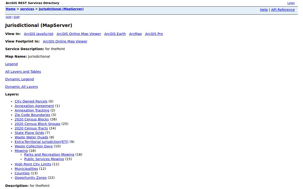
The map layer is context, not a resident list. Its value is in revealing a boundary, parcel relationship, or planning overlay that changes which official office should be consulted next. A High Point postal address may still fall in another county's record system, so city limits and the county line belong in every first check. Verify selected parcel attributes in the county property portal rather than treating the map symbol as an ownership record.
High Point Neighbor Boundaries
Not every nearby parcel is a direct neighbor. The cleanest category is a parcel sharing a boundary with the target. A second category includes parcels across a street or alley, which may face the target but do not touch it. A third category is a same-neighborhood property that is nearby without either relationship. Labeling those categories avoids turning a broad visual radius into a claim of direct adjacency.
- Directly adjoining
- Parcels share a lot line or a point of their mapped boundary.
- Across the way
- Parcels face or sit near the target but are separated by a street or alley.
- Map barrier
- A railroad, stream, future street, condominium parcel, or intervening lot can make visual proximity misleading.
Guilford's Base Map identifies roads, railroads, streams, parcels, city limits, and county lines. Use those layers before adding any parcel to a High Point neighbors list. ZIP and census polygons can describe geography, but they do not establish a neighbor relationship or an address occupant.
High Point Voter Records Nearby
The public NC Voter Lookup requires first name, last name, and at least one status selection. It can be narrowed with a middle initial, year of birth, or county. It does not offer a public street-browse feature, so it cannot produce a complete block list from an address. A match may show public registration, precinct, district, party, and participation-history information, but participation history never shows how someone voted.
G.S. 163-82.10 permits requests for county or precinct voter lists with selectable public fields, subject to actual cost and use restrictions. Address, party, precinct, districts, age rather than date of birth, and history may be available in an authorized list. Social Security number, full date of birth, driver-license or agency identity, email, and protected addresses are confidential. Do not re-identify protected people by combining map and voter results.
Note: Choose the county board only after the parcel map confirms the county for the High Point address.
Map a High Point Neighbor Block
Use the map to establish a small, defensible block of parcels, then open every selected property separately. This is slower than a street-wide export, but the county property interface does not present a verified one-click owner roster for an entire street. It also keeps the process tied to parcel geometry instead of a guess based on postal-city labels.
- Find the target situs address in the county parcel map and record the parcel ID or geometry.
- Turn on city-limit and county-boundary layers, then confirm whether the parcel is in High Point, its ETJ, or another jurisdiction.
- Select parcels that share a boundary or face the same street. Mark across-street and nonadjacent properties separately.
- Check for streams, railroads, alleys, condominium parcels, or another lot that changes the apparent relationship.
- Open each selected parcel in the Guilford property listing to read its own owner, situs, and mailing fields.
The result is a parcel list, not a current-resident list. For a full named-street chain rather than the immediate block, use the High Point street directory, where the address-by-address record trail belongs.
High Point Civic Neighbor Contacts
Neighborhood pages are a useful way to learn how a block organizes itself, but they should not be read as membership directories. The city supports and connects local associations through its Neighborhood Associations program. Oakview offers a concrete example of how official civic information can supply boundaries and a meeting channel without identifying every household.
| Community source | Verified contact or context |
|---|---|
| City Neighborhood Associations | Community & Neighborhood Development support and association sign-up route; an umbrella resource, not a roster. |
| Oakview Citizens' Council | Old Winston Road west, Highway 311 north, Centennial east, and Hartley south; second Monday at 6:30 p.m. at Oakview Recreation Center, 503 James Road. Confirm current meeting details before attending. |
| Neighborhood Watch | Resident-led coordinator model supported by city Community & Neighborhood Development and police community engagement; High Point Police nonemergency is 336-883-3224. |
Oakview's public mission includes city and police communication, National Night Out, town halls, food drives, and prevention work. Those details make it a useful geographic and civic reference, not evidence that a particular person participates in the council or a watch group.
High Point Neighborhood Support
In May 2025, the City of High Point and the Foundation for a Healthy High Point announced support for 11 core neighborhood associations. The announcement described up to $2,000 for each association's community-led mini-initiative, a $22,000 total foundation contribution, and city technical support. It is a current civic-network marker that can help identify an official contact path for High Point neighbors, not an enrollment or resident list.
Historic district information has a different purpose. Johnson Street, Sherrod Park, West High Avenue, Washington Street, Uptown Suburbs, and Highland Cotton Mills Village document development eras, boundaries, or architectural history. Pair a parcel with the appropriate historic-district source when researching the block's past, but do not infer association membership from a district map.
High Point Neighbor Source Comparison
Official records identify the custodian, date, and field that produced a result. Compiled neighbor-finding services may combine public feeds and purchased data, but they can lag behind the original record, merge same-name people, or omit protected information. Use a compiled result only as a lead, then verify it against the government or library record that actually supports the claim.
| Official records | Compiled neighbor tools |
|---|---|
| Show the source type, record date, and stated access limits. | May combine feeds with unclear update timing or matching rules. |
| Parcel card identifies a listed owner for one parcel. | Can confuse ownership, registration, historic listings, and current connection. |
| Protected data remains under the custodian's legal controls. | Does not justify searching for or publishing protected information. |
High Point Neighbor Privacy Limits
North Carolina public-record access is record-specific. Property and voter sources publish some fields while withholding others, and a public address does not erase protections elsewhere. The North Carolina Address Confidentiality Program uses substitute addresses for eligible survivors of domestic violence, sexual assault, stalking, or human trafficking. Chapter 15C requires agencies to keep an actual protected address out of ordinary public records.
G.S. 14-277.3A defines stalking as a willful course of harassment without legal purpose that causes a reasonable person to fear for safety or suffer substantial emotional distress. If a record suggests a protected address or a safety concern, stop the search and use the original custodian's official correction or safety route. High Point Police nonemergency is 336-883-3224, and 911 is for immediate danger.
High Point Block Record Requests
A missing online result does not justify a broad request for personal information. For city-held materials, the High Point JustFOIA portal accepts focused public-records requests, and the city says a requester need not identify themselves or give a reason. Identify the address, record type, date range, and whether an electronic copy is preferred. Send tax, deed, voter, and court requests to their actual county or state custodian instead.
A narrow request can clarify a specific permit, inspection, map layer, or public correspondence record. It cannot turn protected voter data, utility details, private civic membership, or an ACP address into an open block directory. Keep the request tied to a documented public record and a clear address or time period.